Plainfield Town Seal

Town of

Plainfield
, NH

-- choice white pines and good land

Site Navigation

  • Home

    • Home Page
    • Calendar
    • Contacts
    • Town Office
    • Privacy Policy
    • Local Weather
  • Community

    • About Us
    • Business
    • Churches
    • Cornerstones
    • Local Organizations
    • Recreation
    • Schools
    • Special Events
  • Governance

    • Boards/Commissions +
      • Conservation Comm.
      • Joint Commissions
      • Library Trustees
      • Planning Board
      • Select Board
      • Zoning Board
    • Committees +
      • Emergency Mgt.
      • Energy
      • Finance
      • July 4th
      • KUA/Plainfield
      • Meriden Library / Village
      • Parrish Stage Set
      • Plainfield Town Hall
      • Town Garage
    • Town Office
    • Town Officials
  • Services

    • Fire & Rescue
    • Human Services
    • Libraries
    • Police
    • Recreation Dept.
    • Taxes & Registratons
    • Trash & Recycle
    • Water Districts
  • Documents

    • Annual Town Reports
    • Annual Audits
    • Building Inspection
    • Forms
    • GIS System
    • Maps
    • Master Plan
    • Meeting Minutes
    • Nat. Res. Inventory
    • Site Plan Review Reg.
    • Subdivision Regs
    • Tax Parcel Maps
    • Town Policy
    • Zoning & Building

Town Maps

Maps of Plainfield can show different perspectives of our Town and our environment. The maps below are from different sources, but each gives a unique view to consider. We hope you enjoy them all.

Hood-Smith Map of Plainfield

The original map by Vernon Hood was re-made by David Smith and his son. This map shows Plainfield's roads and many of its landmarks. Copies are available at the Town Office.

Hood-Smith map of Plainfield
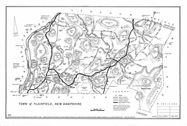
For a larger version, click on the image above.
Interactive Natural Resources Map

This map of Plainfield was prepared by the Upper Valley - Lake Sunapee Regional Planning Commission (UVLSRPC). It has many layers which can be turned on or off in order to see different map and resource combinations. Take a look at the instructions for using this map before you begin.

Interactive resource map
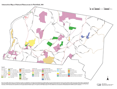
Click on the map above to download a MUCH larger version (7mb).

You can also download a 10mb Version which includes ariel photos. Both maps can be viewed by Adobe reader.


All the Web plainfieldnh.org

Send comments to Plainfield Webmaster

This document was last modified September 22, 2020

Copyright © by the Town of Plainfield